The Sheffield and South Yorkshire Navigation

Click on the page you would like to visit:

Photo Highlights of the Sheffield and South Yorkshire Navigation

A virtual cruise along the Sheffield and South Yorkshire Navigation

The history of the Sheffield and South Yorkshire Navigation

Sheffield Canal Basin

Sheffield and Tinsley Canal

New Junction Canal

Stainforth and Keadby Canal

Vazon Sliding Railway Bridge

Also on Pennine Waterways:

Aire and Calder Navigation

Calder and Hebble Navigation

The Dearne and Dove Canal

The Barnsley Canal

North Yorkshire Waterways

The Rochdale Canal

The Huddersfield Narrow Canal

See the full list of canals covered by this site

Sheffield and South Yorkshire Navigation

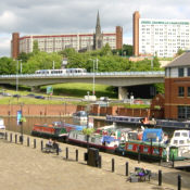
The Sheffield and South Yorkshire Navigation runs for 40 miles between Sheffield, South Yorkshire, and the River Trent, UK.

It is made up of the Sheffield and Tinsley Canal, Don Navigation and Stainforth and Keadby Canal, along with the New Junction Canal.

Locks between Rotherham and the New Junction were enlarged in the 1980s to enable larger craft to use them. A small amount of commercial traffic still uses this part of the waterway. The other parts of the waterway are now used purely for leisure.

Keep Up With Pennine Waterways News

Keep informed of news of canals in the area and about this website.
Join the Pennine Waterways mailing list or see archive of previous newsletters.
Subscribe to the RSS News Feed or receive Email News Alerts in your inbox.

These related books are available from amazon.co.uk - follow links for details:

The Sheffield and Tinsley Canal

by Simon Ogden

Sheffield and South Yorkshire Navigation

by Mike Taylor

The Forgotten Canals of Yorkshire: Wakefield to Swinton

by Roger Glister
photographic history of the Barnsley Canal and the Dearne and Dove Canal

Canals of the Aire and Calder Navigation

by Mike Taylor

For more books about these canals,
click here to visit the Pennine Waterways Book and Map Shop