The Peak Forest Canal

Click on the page you would like to visit:

Photo Highlights of the Peak Forest Canal

A virtual cruise along the Peak Forest Canal

The history of the Peak Forest Canal

Archive Photos of the Peak Forest Canal

Bugsworth Basin

The Opening of Bugsworth Basin

Peak Forest Canal Anniversary Celebrations

Ted Keaveney Memorial Signpost

Memorial Plaque to Dr Cyril Boucher

On-line maps showing the Peak Forest Canal

Also on Pennine Waterways:

The Macclesfield Canal

The Ashton Canal

Waterways in Manchester and Salford

The Rochdale Canal

The Huddersfield Narrow Canal

The Bridgewater Canal

See the full list of canals covered by this site

Peak Forest Canal

The Peak Forest Canal runs for 15 miles between Ashton under Lyne, east of Manchester, and Whaley Bridge, Derbyshire, UK.

It links the Ashton Canal with the tramways that brought limestone from the Peak District quarries.

The canal's terminus at Bugsworth Basin is one of the best-preserved canal-tramway interchanges.

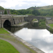
Marple Aqueduct carries the canal 100 feet above the River Goyt.

There are 16 locks ar Marple, separating the "Upper" and "Lower" parts of the canal. The Lower Peak Forest Canal forms part of the "Cheshire Ring".

Keep Up With Pennine Waterways News

Keep informed of news of canals in the area and about this website.
Join the Pennine Waterways mailing list or see archive of previous newsletters.
Subscribe to the RSS News Feed or receive Email News Alerts in your inbox.

These related books are available from amazon.co.uk - follow links for details:

Peak Forest Canal

by Olive Bowyer
(New Mills Local History Society)

Peak Forest Tramway

by D Ripley

Pearson's Canal Companion: The Cheshire Ring 

by Michael Pearson
Ashton, Peak Forest, Macclesfield, Trent & Mersey and Bridgewater canals and Rochdale Nine. Colour photos and diagrams. Clear descriptions. 2009 edition.

For more books about these canals,
click here to visit the Pennine Waterways Book and Map Shop